Big Bear Road Conditions: Live Updates, Highway Routes & Winter Driving Guide
Planning a trip to Big Bear Lake? Big Bear Lake is accessible by several mountain highways, including Highway 18, Highway 330, and Highway 38.
Use this guide to check current road conditions, understand your route options, prepare for winter driving, and travel to Big Bear with confidence.
Big Bear Road Conditions Resources
Check highway closures, chain requirements, and travel alerts before heading up the mountain.
Highways to check:
- Highway 18: Running Springs and Lucerne Valley approaches
- Highway 330: Highland to Running Springs
- Highway 38: Redlands and Mentone through the San Bernardino Mountains

Important: Road conditions can change quickly. Information displayed here is provided for travel planning and may not reflect changes occurring between updates. Always follow posted road signs, Caltrans instructions, and California Highway Patrol directions.
You can also call 1-800-427-7623 for California highway condition information.
You can call the following for roadside assistance.
OFF ROAD RECOVERY (Steve)
Services: Roadside/vehicle-related assistance. Confirm specific services, coverage, and availability before publishing.
Phone: 909-222-0265
Call for availability and assistance.
REBEL OFF ROAD RECOVERY
Services: Fuel, Mechanic (mobile and shop), snow removal, roadside assistance, chain assistance, tire changes, Recovery or removal from snowed out driveways and battery services.
Phone: 951-542-4714
Website: https://rebeloffroadrecovery.com/
How to Check Big Bear Road Conditions Before Your Trip
We recommend checking road conditions several days before your visit, again the evening before departure, and once more immediately before leaving.
Three Main Routes to Big Bear Lake
Big Bear Lake can be reached by three scenic mountain routes. The best option depends on where you’re traveling from, current highway conditions, and your comfort with mountain driving.
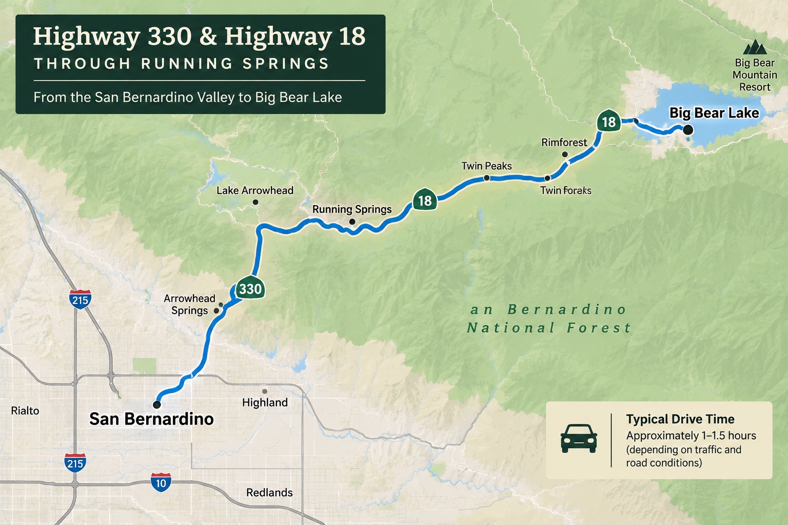
Highway 330 and Highway 18 Through Running Springs
Highway 330 connects the San Bernardino Valley with Running Springs, where travelers continue toward Big Bear on Highway 18.
Best for: visitors traveling from Los Angeles, Orange County, and the Inland Empire.
The drive features mountain scenery, winding roads, and significant elevation changes. Traffic can become heavy during weekends, holidays, and busy winter periods.
Highway 18 Through Lucerne Valley
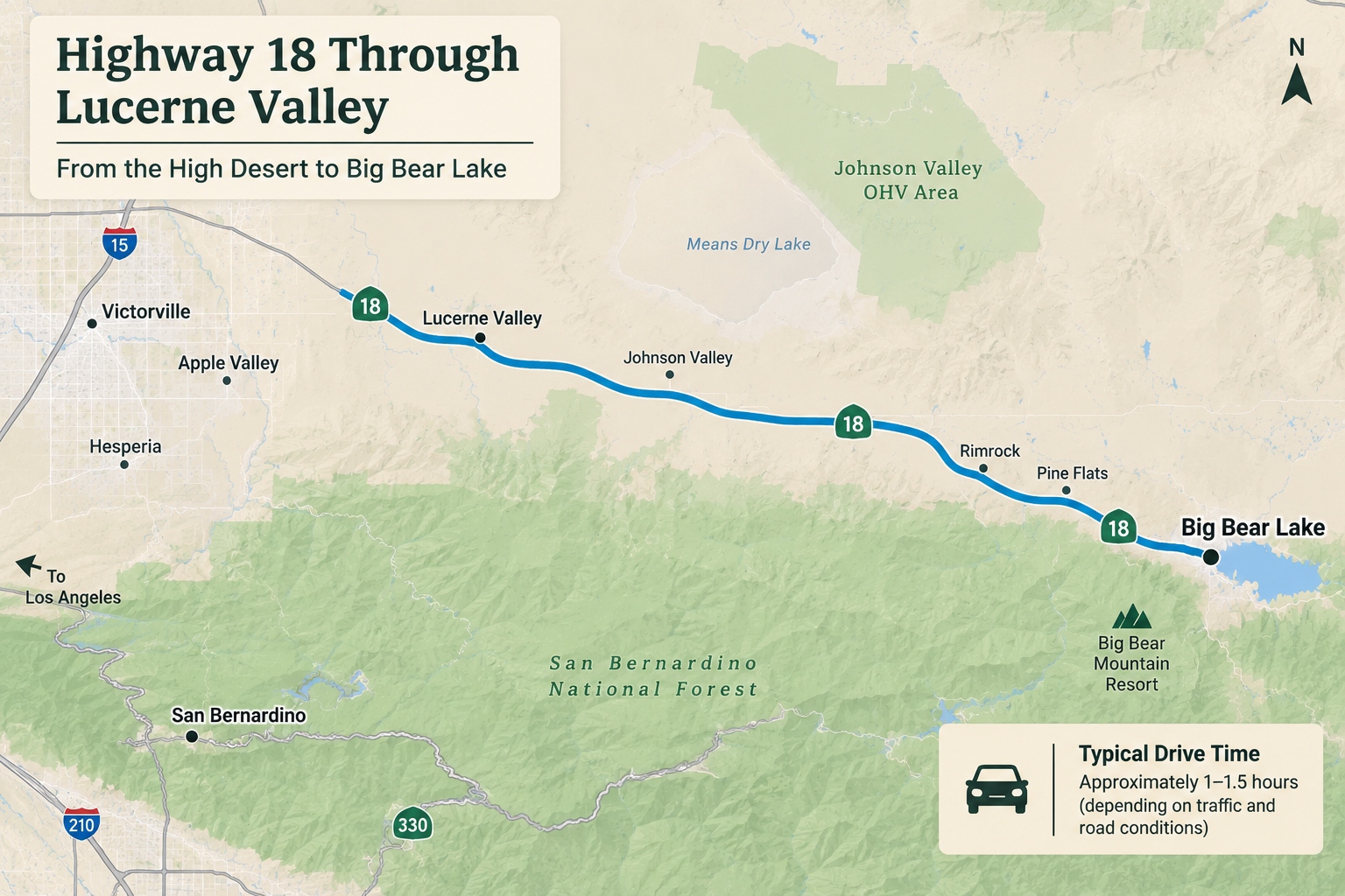
Highway 18 provides an approach to Big Bear from the High Desert through Lucerne Valley.
Best for: Visitors approaching from the High Desert or travelers evaluating an alternate route based on current conditions.
This route is often considered by visitors coming from Victorville, Barstow, Las Vegas, and surrounding desert communities. It may also be an alternative when other mountain approaches are affected by closures.
Although it approaches Big Bear from a different direction, it still includes mountain grades, curves, and potentially icy or snowy roadways.
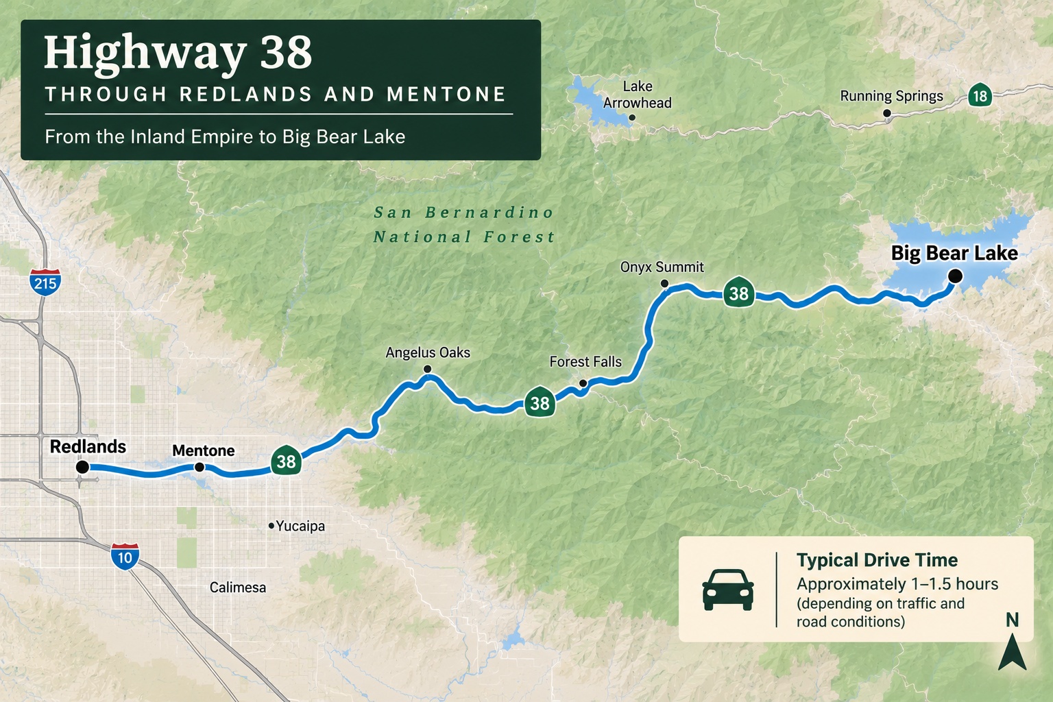
Highway 38 Through Redlands and Mentone
Highway 38 provides another scenic route into the Big Bear Valley, traveling through the San Bernardino Mountains from the Redlands and Mentone area.
Best for: Visitors approaching from Redlands, Mentone, and nearby communities when the highway is open and conditions are suitable.
This route passes through forested mountain landscapes and is sometimes considered by visitors who prefer an alternative to the Running Springs approach.
Highway 38 may be affected by construction, storm damage, maintenance, or weather-related restrictions.
Travel tip: No single highway is guaranteed to be the fastest or safest in every storm. Always choose your route based on current official road conditions.
Do You Need Snow Chains to Drive to Big Bear?
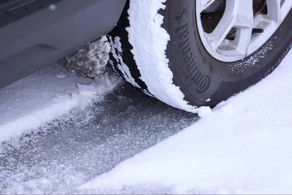
Yes, snow chains or approved traction devices may be required when winter conditions affect mountain highways.
Even vehicles equipped with four-wheel drive or all-wheel drive may need to carry traction devices when entering chain control areas.
Requirements depend on the posted restrictions, vehicle type, tires, and current road conditions.
Understanding California Chain Control Levels
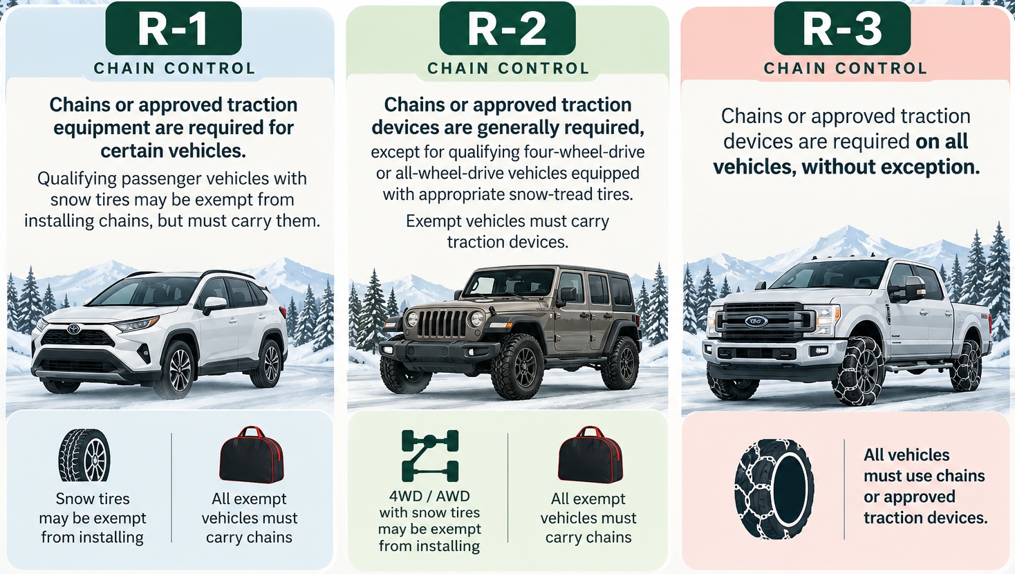
Always follow posted signs and instructions from Caltrans or the California Highway Patrol.
For full requirements and exceptions, visit Caltrans Chain Control Information.
Can You Drive to Big Bear with AWD or 4WD?
Yes, many visitors travel to Big Bear in all-wheel-drive or four-wheel-drive vehicles. However, having AWD or 4WD does not eliminate the need to prepare for snow and ice.
Depending on conditions, you may still be required to carry or install approved traction devices.
Check your vehicle manufacturer’s instructions before purchasing or installing chains, as some vehicles have specific clearance restrictions.
Winter Driving Tips for Big Bear
Winter in Big Bear can bring beautiful snowy landscapes, but mountain driving requires preparation.
Before traveling during winter weather, make sure your vehicle is ready for cold temperatures, changing visibility, and potentially slippery roads.
Your Mountain Driving Checklist
- Check tire tread and tire pressure.
- Inspect brakes, windshield wipers, headlights, and defrosters.
- Carry compatible tire chains or approved traction devices.
- Practice installing chains before your trip.
- Keep your fuel tank adequately filled or your EV sufficiently charged.
- Bring water, snacks, warm clothing, and blankets.
- Pack a flashlight, ice scraper, gloves, and a small shovel.
- Allow extra travel time.
- Reduce your speed and increase following distance.
- Avoid sudden braking or sharp steering on snow and ice.
Whenever possible, plan your mountain drive during daylight hours, especially if you’re unfamiliar with the roads.
Watch for Ice, Fog, and Changing Conditions
Mountain weather can change rapidly, and roads may become slippery even when snowfall has stopped.
Shaded areas, bridges, and higher elevations can remain icy after nearby pavement has dried.
Fog may also reduce visibility, while fallen rocks and storm debris can create additional hazards.
Drive cautiously, use designated turnouts when appropriate, and never stop in active traffic lanes to take photos or play in the snow.
What Happens If Roads to Big Bear Close?
Road closures may occur because of winter storms, traffic accidents, maintenance, construction, or other safety concerns.
If your planned route closes, check Caltrans for current restrictions and available alternatives. Do not assume another mountain highway is open without confirming its status.
If all practical routes are affected, wait until conditions improve rather than attempting an unsafe detour.
Already booked a cabin? Review your reservation agreement and contact Destination Big Bear if you have questions about your upcoming arrival. Reservation policies and any applicable exceptions depend on your booking terms.
Frequently Asked Questions About Big Bear Road Conditions
Road conditions change throughout the day. Use the live road information section above or check Caltrans QuickMap for the latest reported closures, chain controls, and traffic incidents on Highways 18, 330, and 38.
Big Bear is accessible throughout the year, but individual highways may temporarily close because of snowstorms, accidents, construction, or other conditions. Always verify your intended route before traveling.
The most convenient route depends on your starting location and current road conditions. Highway 330 and Highway 18 through Running Springs are commonly used by visitors from Southern California, while Highway 18 through Lucerne Valley serves travelers approaching from the High Desert. Highway 38 provides another mountain approach when open.
You may still need to carry chains or approved traction devices. Some properly equipped four-wheel-drive and all-wheel-drive vehicles are exempt from installing them under certain chain control levels, but restrictions can change. Always follow posted requirements.
Safety depends on the severity of the storm, highway restrictions, visibility, road conditions, and your vehicle’s equipment. Check official weather and road reports before departing, and consider delaying travel during severe conditions.
Navigation apps can help with directions and traffic estimates, but Caltrans should be your primary reference for official highway closures and chain controls.
Check Caltrans for the affected section and current restrictions. Depending on your starting location and conditions, Highway 18 through Lucerne Valley or Highway 330 and Highway 18 through Running Springs may be alternatives. Confirm that your selected route is open before departing.
Visit the National Weather Service for forecasts, watches, warnings, and other weather information affecting the Big Bear area.
Plan Your Big Bear Getaway with Destination Big Bear
Once you’ve checked the road conditions and planned your route, it’s time to enjoy everything Big Bear Lake has to offer.
From winter ski weekends and cozy fireplace retreats to summer lake adventures and colorful fall escapes, Destination Big Bear offers a wide selection of vacation rentals for couples, families, and groups.
Explore mountain cabins, lakefront retreats, pet-friendly homes, and spacious properties designed for memorable Big Bear getaways.
Before you travel: Bookmark this road conditions guide and check official highway updates before departing. A little preparation goes a long way toward a safer, more enjoyable mountain getaway.
Find a Cabin Rental in Big Bear Lake